


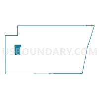
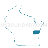
CATO - T 1 Voting District, Manitowoc County, Wisconsin
About
Outline

Summary
| Unique Area Identifier | 694699 |
| Name | CATO - T 1 Voting District |
| County | Manitowoc County |
| State | Wisconsin |
| Area (square miles) | 18.75 |
| Land Area (square miles) | 18.56 |
| Water Area (square miles) | 0.18 |
| % of Land Area | 99.01 |
| % of Water Area | 0.99 |
| Latitude of the Internal Point | 44.11529360 |
| Longtitude of the Internal Point | -87.88962370 |
Maps

Graphs
Select a template below for downloading or customizing gragh for CATO - T 1 Voting District, Manitowoc County, Wisconsin


Neighbors
Neighoring Voting District (by Name) Neighboring Voting District on the Map
- CATO - T 2 Voting District, Manitowoc County, WI
- EATON - T 1 Voting District, Manitowoc County, WI
- FRANKLIN - T 2 Voting District, Manitowoc County, WI
- LIBERTY - T 1 Voting District, Manitowoc County, WI
- MAPLE GROVE - T 1 Voting District, Manitowoc County, WI
- ROCKLAND - T 1 Voting District, Manitowoc County, WI
- ROCKLAND - T 2 Voting District, Manitowoc County, WI
- Valders - V 1 Voting District, Manitowoc County, WI
- Whitelaw - V 1 Voting District, Manitowoc County, WI
Top 10 Neighboring County Subdivision (by Population) Neighboring County Subdivision on the Map
- Cato town, Manitowoc County, WI (1,566)
- Liberty town, Manitowoc County, WI (1,281)
- Franklin town, Manitowoc County, WI (1,264)
- Rockland town, Manitowoc County, WI (1,001)
- Valders village, Manitowoc County, WI (962)
- Maple Grove town, Manitowoc County, WI (835)
- Eaton town, Manitowoc County, WI (833)
- Whitelaw village, Manitowoc County, WI (757)